Walking up and down mountains and through rivers and valleys is a romantic notion. I really had no idea what to expect embarking on the 8-10 day trek in Nepal that someone else (thankfully) had arranged.
A brief background which provides some context to one of the most enriching experiences of my life and a reaffirmation of all that is good in this world.
Nepal, a mountainous land-locked Himalayan nation (adjectives much?) has a large porous border with India and surrounded by the latter on the North, West and South with the eastern border completely taken by Tibet (China).
The National Trust for Nature Conservation (NTNC) in Nepal has put a lot of heart and soul into the Annapurna Conservation Area Project (catchy acronym ACAP).
The reason for boring you with these details is that the ACAP work stood us in good stead throughout our time in Nepal and one can only marvel at this organization’s efforts to mark often obscure trails to ensure no one gets lost.
Day 1 (14 km)
 |
| Pokhara Airport |
The porters on the other hand are made of sterner stuff. Each of our duffel bags weighs upward of 15 kg and the porters expertly tie two duffel bags together and effortlessly haul the loads and are off at a pace which we lesser mortals (with nothing to carry) can only dream of.
 |
| First Lunch |
 |
| On the way to Ulleri |
Day 2 (10 km)
The day dawns bright and cloudless and we catch our first glimpse of one of the behemoths that Nepal is known for. Annapurna South, peaking at an impressive 7219 m looms over the the smaller mountains and it is one awe inspiring sight and I introspect human insignificance against the mighty mountains. Hiunchuli at 6441 m is the other large mountain that's clearly visible from our night abode.
 |
| Lunch |
 |
| Ghorepani Hotel |
The Nepali definition of a gradual climb is not for the unprepared. Sometimes, not knowing what to expect maybe good as we complete the ‘gradual’ climb into Ghorepani by late evening. Here, at 2800m, we get a much better view of Annapurna South and it’s a view of which I could never tire.
With my tummy tribulations, I take lots of rest and very little food that night.
Day 3 (18 km)
The rest of the team decide to brave the elements (icy cold and a thick mist) at 4:30 a.m to climb up Poon Hill (3200 m) for a better view of the mountains. I opt to sleep in.
 |
| From the hotel in Ghorepani |
One thing you learn during trekking is that no one and no sign ever speaks of distances with the usual measures. Distances are always measured by time which is meaningless as our group stops for photos at the drop of a hat and takes frequent rest stops.
 |
| Ghorepani to Tatopani |
 |
| Ghorepani to Tatopani |
 |
| Suspension Bridge over Kali Gandaki |
During a restroom break in the great outdoors I catch a glimpse of a large snake but I’m unable to get a picture. We cross a steel suspension bridge hanging over the famous Kali Gandaki river. The last few kilometers are by ‘motorable’ road and we reach Tatopani (elevation 1100 m) after over 9 hours of walking, eating and resting.
 |
| Hotel at Tatopani |
The 18 km walk in conjunction with my twisted foot replaces my stomach ailments and my foot feels like lead now. I still limp nimbly to the fabled hot-spring of Tatopani where we are met by a small rectangular swimming pool like concrete enclosure with predominantly topless men smoking and chugging down a few. Undaunted, we slide ourselves inside the pool which does indeed have warm water though I am suspicious that there’s an electric/gas heater powering this all.
Day 4 (10 km)
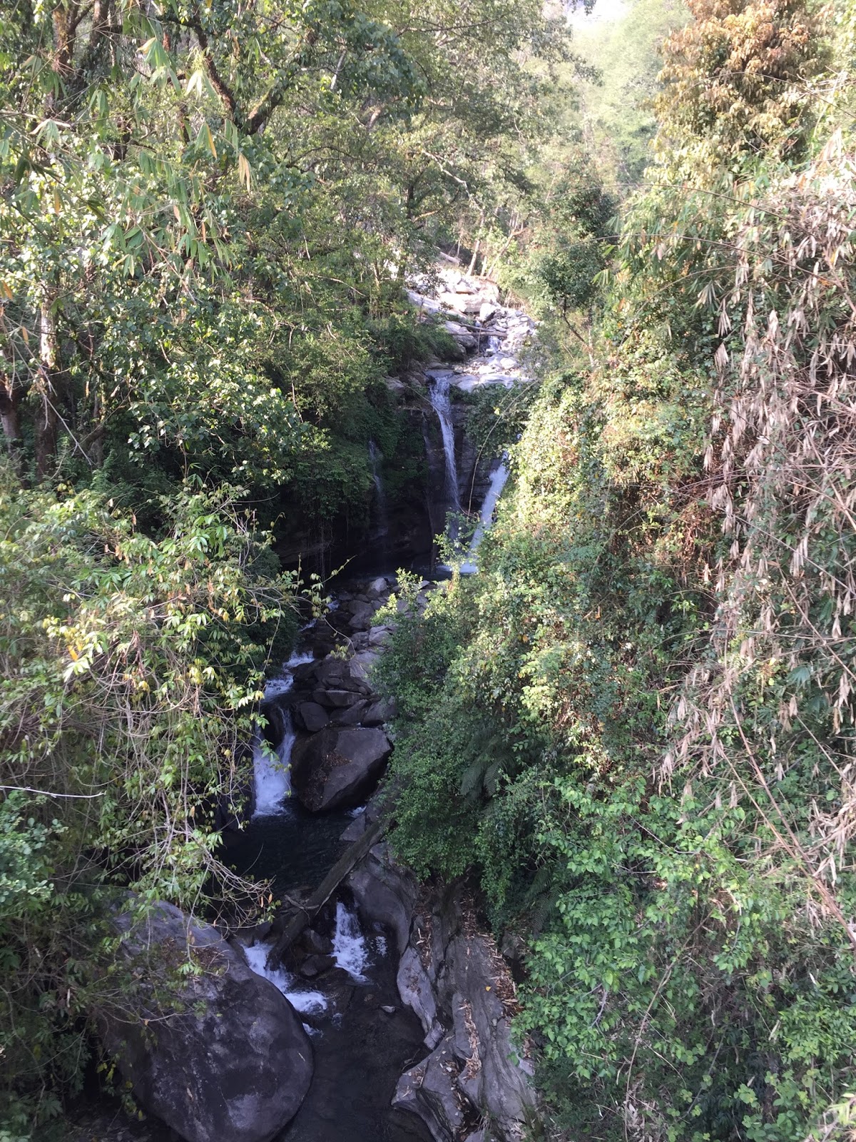
Our next destination is Ghasa, supposedly another 5-6 hour walk but of unknown distance. We come across a powerful waterfall (Rupse Chahara, 300m height) with a roar clearly being heard deep in the valley where we pause for our meals. The deepest gorge in the world - Kali Gandaki gorge is right here too.
A slight drizzle now turns into a regular downpour temporarily suspending further walking activities and we use this time wisely - eating and drinking some more in the small (German Bakery) tea lodge ensconced between the waterfall and the gorge.
The waterfall hitherto cascading pure white water now turns a chocolate brown indicating the severity of the rains in the mountains. My foot is now almost immobile and a stick and poncho are feeble measures against the elements and the sprain. The group takes a vote (without me) that I need to take a bus to Ghasa about a few kilometers away. We hail a passing bus which already is bursting at the seams and tilting dangerously to one side. The lead guide and I clamber on and miraculously make space for ourselves albeit standing. We also are the proud possessors of a doko which is a large bamboo basket holding all our day packs. The next fifteen minutes are the scariest of my life. The rain has not let up fully, the ‘motorable’ road is narrow and comprises of flowing mud and stones. Ghasa is higher up than Tatopani and with the Kali Gandaki river a few thousand feet below us, every curve we take I feel will be my last. The driver nonchalantly handles the bus like a kid would a RC vehicle and even turns back to exchange pleasantries with the conductor and other passengers. All this while dangerously maneuvering the bus through stomach churning blind turns and oncoming traffic which pretty much comes down in similar fashion.
We finally reach Ghasa (elevation 2100m) without incident other than the fact that the bus stops about 500m ahead of our hotel stop. With my poncho fighting a losing battle against the rain and wind, stick in one hand. limping terribly and the guide carrying the basket with two hands, we comically make our way back to the hotel.
A slight drizzle now turns into a regular downpour temporarily suspending further walking activities and we use this time wisely - eating and drinking some more in the small (German Bakery) tea lodge ensconced between the waterfall and the gorge.
 |
| The Rupse Waterfalls |
 |
| After the rains |
 |
| Our hotel in Ghasa |
I take a good nap waking up to hot tea and biscuits while the wife and the rest of the team have a chance meeting with a German that would irrevocably change our plans for the rest of our trip.
No comments:
Post a Comment