Sunday, April 30, 2017

Annapurna Semi Circuit (The culmination)

With modernization comes the perils of deforestation and destruction of some of the most beautiful trails Nepal has to offer. Lovely routes meandering through the wilderness and often stark landscapes have been overpowered by mud roads. 

The New Annapurna Trekking trail (NATT) is the brainchild of a Belgian born German Andrées de Ruiter and Prem Pai a Nepalese trek guru. The sole purpose of NATT is to create trekking routes for those not inclined to suffer the umbrage of pollution spewing motor carriages. The two aforementioned gentlemen actually looked for alternative routes away from the roads and marked the routes at regular intervals with red and white paint. Commitment of this ilk is something else. Imagine walking with a bucket of paint for hundreds of miles just to make it easy for trekkers to navigate away from the dust and decibels! Well, that’s what they did and the NATT stands out as a lifesaver for the myriads of walkers that dot the country’s trails.


If you haven’t read part 1 of our exciting journey through the entrails of Nepal, it doesn’t matter. But here we stop the day numbering business of part 1 as each day in the remaining narrative deserves a more descriptive heading. 

Alright, here goes…

In which we change the rules of engagement (Ghasa-Lete-Marpha)

David is a German lad whom the wife runs into at our hotel in Ghasa. He’s doing the full route anti-clockwise and tells us about hidden off-road routes. Already sick of walking on the motorable road from Tatopani to Ghasa and with the impending walk to Marpha on the same road, we latch on to David’s story and dig deep into his trekking routes and his English vocabulary. He expounds on the Blue and White marked routes which are side trails and NATT trails that we were unaware of.

It doesn’t take long for us to be convinced that we need to take a less trodden route to Marpha. A plot is hatched in the well lit and cosy interiors of Eagle’s Nest restaurant; we huddle around mobile devices and maps as we plan our foray into the great unknown. 

David shares this miraculous PDF which reveals the wonderful world of NATT. We figure out that we can get part way to Marpha without battling the roads. Excitement galore but who will bell the cat? There’s mutiny brewing in the guide ranks as they are convinced they need to follow the route that has been pre-planned. We cajole and smooth talk them into taking the different route. Not convinced but with not much choice, they reluctantly agree but with a few thousand disclaimers. We brush these aside as nothing will make us walk those diabolical dust traps again.

Trek from Ghasa
My foot fully healed, my stomach working like a well oiled machine (okay, maybe not the right analogy), we set off around 8:30 a.m from Ghasa.

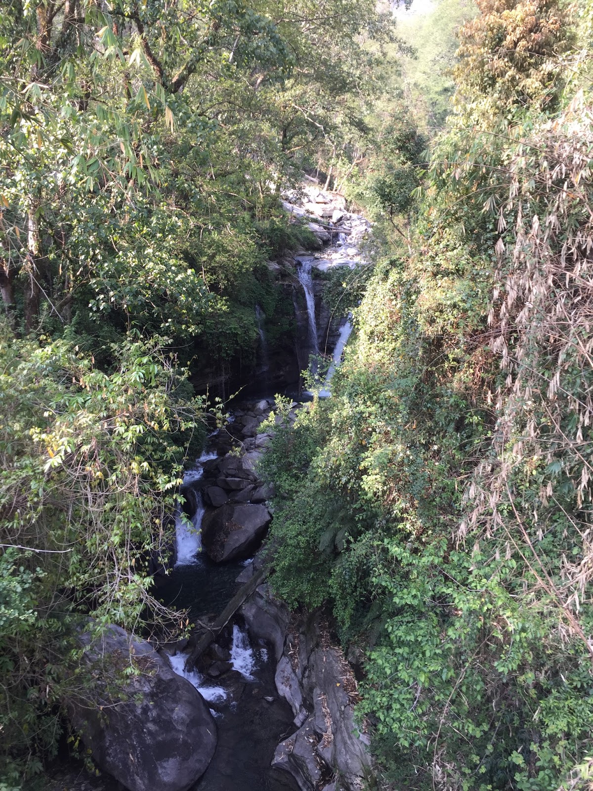
The sharp sun and the incisive cold make a merry combination for a comfortable jaunt. First we walk down a stony path to another one of those suspension bridges and then it’s an up and down walk on the side of a mountain (okay, hill as apparently you can only call it a mountain if it has snow on it). There are innumerable pine trees on the forest path on the hills with the Kali Gandaki river flowing below and the multitude of soaring Himalayan peaks (Annapurna South, Annapurna I, Nilgiri South and Tukuche peak to the east) gleaming in white snow in the distance. The walk itself is not very tough as the ascents are actually gradual with some scary steep parts and there are a lot of slopes to walk down on. A heavenly walk through forests with the aroma of fresh pine and wet grass. Bamboo trees adorn the path and the ensemble is magical.

A few hours of walk and we spot a small hut that is part of a village slightly hidden below. This basket weaving village makes extra income by providing bottled soda drinks for the few trekkers adventurous enough to try this route. We happily gulp down Cokes and Sprites.

And then starts a climb up a really large mountain-like hill. Not very steep but a relentless climb.  The roar of the river under us in unison with echoes from the great walls of the mountain make for an interesting surround sound mixed with the voices of birds. The path, wide in most parts for two people to pass, at times getting narrow needing watchful treads in the blowing wind. Nary a living soul did we pass here.

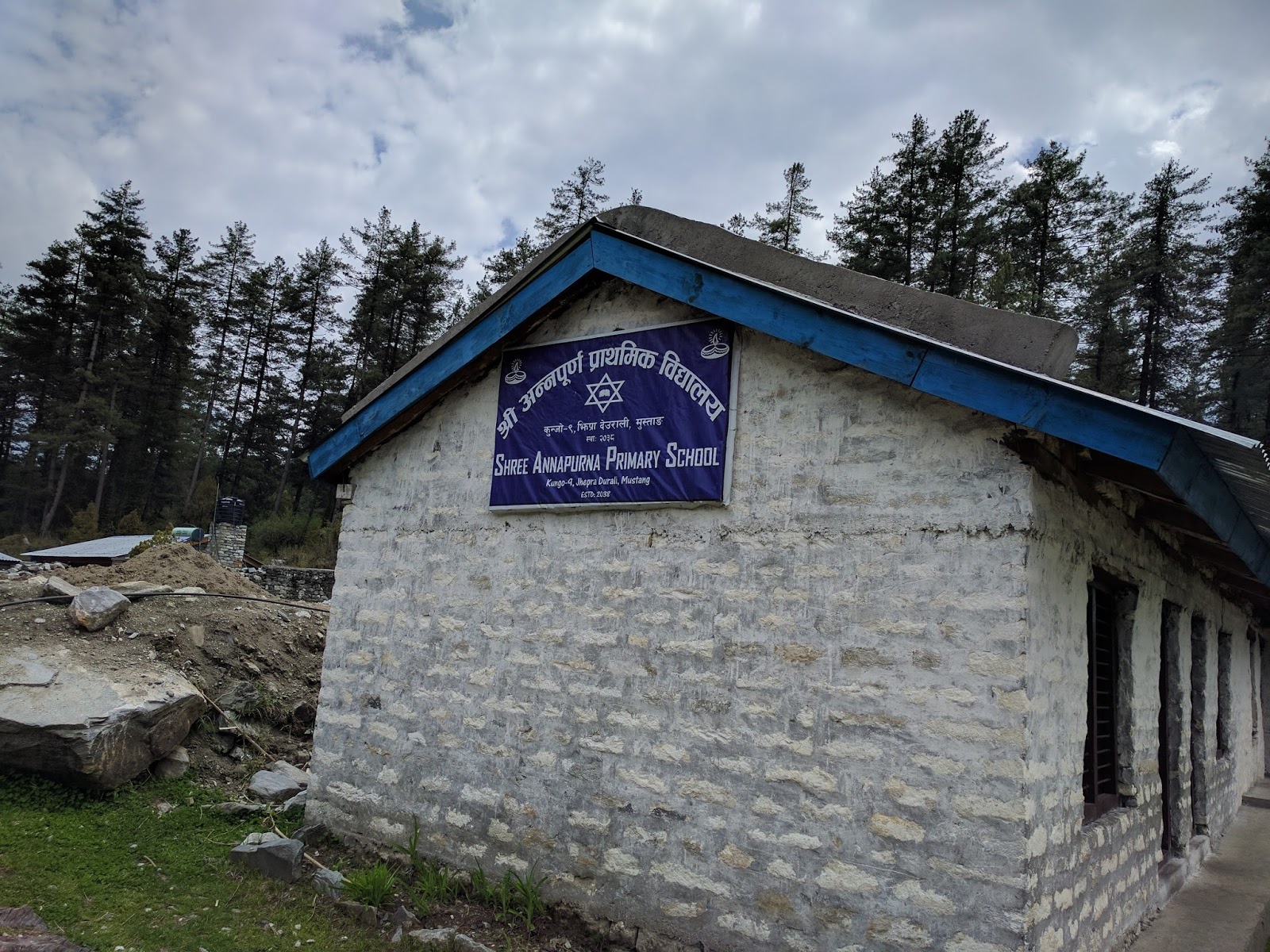
A couple of hours of this immensely satisfying climb and we reach a plateau. Everyone is famished and we stop at the little village of Jhepra Durali (might be butchering the spelling here). The makeshift restaurant here has a small primary school opposite it where I take pictures of the classrooms reminiscent of pre-Independence era schools in India. 

Primary School
We spend a good few hours in Durali as the wife and husband duo cook for us with delicious smells wafting out of their pots; we eagerly await a few yards from the action inside their large kitchen/dining room. A shy little girl (Namrattha) plays with us making sure to keep just out of reach, though she does acquiesce for a quick photograph.

Classroom
Sumptuous doesn’t really cut it when it comes to describing the food.  Boiled and salted spinach doesn’t sound appetizing but boy was this good! As was the dal, and the egg curry with white rice. We attack the food with gusto throwing caution to the winds. We finally set off on the second leg of our journey crossing the dry Titi Lake, a hamlet (Chhayo), over a suspension bridge over the Lete river and finally onto the dreaded main road. 

Dry riverbed crossing
Near Lete
As we hit the road, something doesn’t seem right and realization dawns that we have done six hours of walking and covered an actual distance that would have taken an hour and a half (from Ghasa to Lete) .But what the hell! We relished every minute of the six hours. And may I add, we didn’t see a single trekker on the entire route!

Lete village lies on the main road. Being weary of foot and sore of body, we decide to jump onto a bus to Marpha.


Bus on the River
If my first bus ride was scary, the second takes it to another level. Not only is it a much longer ride, but sitting on the last row which is is a bare bones wooden bench with some pillows thrown on it jumbles our internal organs in unimaginable ways. At one point, our driver decides that the road doesn’t pose enough of a challenge and swerves right and onto the Kali Gandaki. Mind you, it’s not a dry river bed but a real river with flowing water. A passenger protests as his stop is on the wayside of the road. I mean, seriously, who lives near the road when the river beckons so benevolently. Anyway, the driver reluctantly stops in the river and the passenger gets out amidst much muttering and cursing.

We continue on our bronco ride till the town of Marpha (2650m elevation and in the Mustang District) where the wife promptly starts throwing up the minute she gets off the bus.

Marpha
Marpha is beautiful village from the 1700s and apparently a model one in terms of its cleanliness. The entrance to the village is adorned with prayer wheels. A town crier walks up and down the streets telling folks of a visiting doctor from Pokhara in a musical voice.

There are probably about a thousand residents here. Marpha is considered to be the apple capital of Nepal. Apple orchards abound aplenty in this region and they are a sight to behold. The Thakali community lives here and the houses are decidedly different from what we’ve seen thus far. The top of each house has neatly arranged layers of wood logs no doubt to protect agains the harsh winter snow.  Unfortunately, I can’t make a trip to the Nyingma monastery which sits high above the town. Something for another trip.

Did I mention them apples. Well, the freshly squeezed apple juice here is to die for. Two of the group members also partake in the local apple brandy brew and Khukri rum

The night ends with a lukewarm water bath and the wife suffering considerable stomach pain with a still unknown cause.

The cheat day

Today we decide that there’s no walking to be done as the wife is in bad shape. We decide to take a jeep to our next dusty destination of Jomson (elevation 2700m) which is the capital town of the Mustang District. The other three pick yet another NATT route to get to Jomsom much to our guides’ chagrin. 

Jomsom Hospital
View from the hospital
We get the lady treated in the Jomson hospital which has  a grand total of two patients admitted for something that obviously requires admission but otherwise the hospital is empty. The view of the Dhaulagiri mountain from the hospital is clear and breathtaking. Wife is finally let off with a clean bill of health after a couple of hours of IV fluids, some suspect mushroom soup, a couple of pills and few words of caution. Apparently just a mild case of gastroenteritis.

An otherwise uneventful day for us ends in the Himalayan Java Coffee cafe where the barista makes a mean macchiato and plays lovely tunes on his keyboard and guitar.

Three villages and a pass

Finally, everyone is healthy and fit. After poring through the now bible like PDF, I discover a side trail  (blue/white markings) on the Jomson to Kagbeni (elevation 2800 m) route that shows much promise. Again, the tête-à-tête with the guide as he says they don’t know this trail and is against deviating from their path to salvation. We overrule them (as usual) and take a jeep to Eklebhatti bridge a mere 8 km drive from Jomsom towards Kagbeni. 

Eklebhatti bridge
New born goat
First over the suspension bridge spanning the Kali Gandaki river (there’s really no getting away from it on the Annapurna Circuit) and a short while later we are in the village of Pakling. Other than a lady washing clothes and a large dog which takes exception to our presence, we see no one. The dry stony path leads up towards the village of Phalyak. An elderly man is walking down with a new born goat which still has it’s umbilical cord intact. I can’t resist but touch the little fellow and the mother goat providing the security cordon is agitated. We move on.


A personal milestone
Dhakarjhong
The land gets drier and stonier as we ascend to the next village of Phalyak but the views of the mountain only get better. We are already at 3000 m and the altitude begins to tell on one of our group members. We soldier on to the last village on this route going down towards a rivulet with crystal clear water and then up to Dhakarjhong. What an amazing entrance to a village! First of all it sits at 3200 m and the entrance to the village is a cave with well cut stones forming the walls and ceilings of the walk through cave. Small doors on the sides of the walls lead off into homes and storage spaces. I try to capture it all on camera as best as I can. A channel comes up with gushing icy cold water and we reach a large man made pond. Here local women wash clothes amidst village banter. As is our wont during our walks, we are now very very hungry.
Drying Yak Meat
Sachin, our ever enterprising leader, finds a lady who tells us of another lady who is willing to cook for us. We pretty much take over her house, my wife occupies one of the bedrooms and I the dining room and push it by asking for a blanket which they readily oblige with.
A short catnap is interrupted by the call for lunch. We are served by Lakshmi Didi the warm hostess of the house. I try yak meat for the first time and I am hooked. The yak is dry and deep fried with spices and oil and makes a lethal combination with white rice. Maybe it is the hunger but the hot food hits the spot.

The lesser known Batase Bhanjyang also called Windy Pass is a Mecca that I had omitted mentioning earlier. We had read about it in the pdf and it seems like an utopian dream to get to it as no one we talk to knows about it. 

Now, in the village of Dhakarjhong, we learn about the tower that we can see higher up above. This is indeed the mystical windy pass and Laxmi Didi tells us that it’s about a 45 minute walk up. 

The excitement palpable, we launch into our final climb which looks easy but is quite challenging especially with bellies full of Laxmi Didi’s delicious delectables.

The windy pass sits at 3450 m and from here Jomson is in plain sight. The wind is of such force that one can lean back into it and not fall backwards. On a clear day, you can see Upper Mustang, Thorong La, Tilicho peak, the Nilgiri, Daulagiri and Tukuche peaks. We are not so lucky and we only get a brief glimpse of Daulagiri and an even briefer glimpse of Thorong La. There are satellites and communication towers on the pass and nothing else.

View from Kagbeni lodge
Our souls appeased and with general contentment all around, we get back to Dhakarjhong where Laxmi Didi gives us hot tea for our efforts.

We then trudge back to the Eklebhatti bridge and catch a passing bus to Kagbeni without much fanfare.

Kagbeni is small town akin to Marpha but a little more commercial in its appearance. There are narrow lanes and by-lanes that go through the town and the place is filled with little cafes and restaurants. The forbidden (you need to buy a $500 pass) Upper Mustang begins somewhere here and the town overlooks the Kali Gandaki river and of course the omnipresent Daulagiri.

Where we thumb our noses at walking

Muktinath Temple
General consensus on the eighth day in Kagbeni is that we’re done with our trekking. We decide to take a jeep to Muktinath (elevation: 3800 m), our final destination. There are a collection of shrines on the top, the main deity being Shiva. The entrance is decorated by random Indian looking Sadhus awaiting financial freebies.

More of the temple
Fortunately, there isn’t much crowd and we get to see a couple of the shrines and the big sitting Buddha and have some amazing food in a Reggae bar and restaurant at the base of the hill.

The fading light of dusk now makes the drive back to Jomsom a bit edgy and is compounded by a stuck jeep which our driver tugs out of the water. I proudly put my Swiss army knife to its first productive use of its life as the tow rope made of the Hulk’s bones refuses to be untied by human hands.

The night has fallen and I strongly believe our driver is driving by instinct rather than by sight. My data point is that at a certain phase of our journey we are actually driving ON the Kali Gandaki river itself with the flow, on the flow and for a length of time that is not natural to be driving in river.

Somehow, we reach Jomsom where our hotel has been overpowered by a large pilgrimage group from Tamil Nadu.  They are dishing out bise bele baath, curd rice and stuff that we are all dying to get our hands on. My lady decides to go ask for a plate and is handed a full plate of South Indian food with no questions asked.

Flight of fantasy

View from Jomsom Airport
True Heroes - Our Porters
 The small JetStream plane seats about 20 people. There is no door to the cockpit and various machinations performed by the pilot and co-pilot do is visible to all. It’s a lovely take off on one of the smallest runways I’ve ever seen. All the peaks that have been our companions the last 9 days surround us in all their splendor and we get great views once again on both sides.

Cockpit view
Back to Pokhara after an amazing time with our own custom routes thrown in for good measure.


What next? Upper Mustang calls...

Friday, April 28, 2017

The Annapurna Semi Circuit (Part 1)

Walking up and down mountains and through rivers and valleys is a romantic notion. I really had no idea what to expect embarking on the 8-10 day trek in Nepal that someone else (thankfully) had arranged.

A brief background which provides some context to one of the most enriching experiences of my life and a reaffirmation of all that is good in this world.

Nepal, a mountainous land-locked Himalayan nation (adjectives much?) has a large porous border with India and surrounded by the latter on the North, West and South with the eastern border completely taken by Tibet (China).

The National Trust for Nature Conservation (NTNC) in Nepal has put a lot of heart and soul into the Annapurna Conservation Area Project (catchy acronym ACAP). 

The reason for boring you with these details is that the ACAP work stood us in good stead throughout our time in Nepal and one can only marvel at this organization’s efforts to mark often obscure trails to ensure no one gets lost.

Day 1 (14 km)
Pokhara Airport
In Pokhara, Mountain Monarch, our guide company efficiently distributes our duffle (or dufflel?) bags each containing within its cavernous interior a sleeping bag, jacket, blanket, a large plastic bag and the all important toilet paper.

Our walk starts with a drive. About an hour or so from Pokhara lies the small town of Nayapul. Most serious trekkers do the anti-clockwise route commencing from Besisahar to the east of Pokhara and complete the full circuit in ~16 days. Our group of five is a novice group and we elect to do the clockwise route but only half the circuit (hence the clever title). 

We have three porters and for some unfathomable reason - three guides though our ring leader Sachin had clearly instructed that we need three porters for our duffel bags, 2 porters to carry our day packs and one guide. Anyway, details details; we got what we got. Of the three guides, one of them is a teenage kid whose sole purpose is to carry a small red medical pouch which apparently houses cures for any and all deadly diseases we may encounter during our travels. With the colorful name Tasveer (picture in Hindi), he seems to serve no other purpose other than a free internship with our hapless group.

The porters on the other hand are made of sterner stuff. Each of our duffel bags weighs upward of 15 kg and the porters expertly tie two duffel bags together and effortlessly haul the loads and are off at a pace which we lesser mortals (with nothing to carry) can only dream of.

First Lunch
We trudge our way up grassy slopes and tree laden lands and ascend gradually, passing trekkers coming the other way, some passing us and we scarcely passing anyone. Greenery gives way to a muddy road cut in the mountain. We reach Tikhedunga for our first exposure to dal bhat  (lentils and rice), our comfort food for days to come. Blissfully unaware of the remaining hike to follow, I stuff myself with rice, lentils and noodles to account for 10 kms of walking (the furthest I have walked in a day). Needless to say, the second part of the hike is killing. For one, it is an incredibly steep incline heading to Ulleri our next stop. And my stomach isn’t quite right with the overload of carbohydrates and it reflects in my struggles to take on the never-ending steps of varying heights of unstable stone.

On the way to Ulleri
We make it to the sleepy town of Ulleri (elevation 1300 m) where we are welcomed by our first overnight stay hotel called Meera (tagline: Stay in a best place). Our group of two couples and a single guy is then asked to share a restroom (only one bedroom had an attached facility) which results in much friction (an ominous portend of the conflicts to follow) with the lead guide who provides us some amazing logic for our predicament. To add another level of excitement, my stomach is now in full rebellion and I spend the better part of the cold night on the throne.


Day 2 (10 km)
The day dawns bright and cloudless and we catch our first glimpse of one of the behemoths that Nepal is known for. Annapurna South, peaking at an impressive 7219 m looms over the the smaller mountains and it is one awe inspiring sight and I introspect human insignificance against the mighty mountains. Hiunchuli at 6441 m is the other large mountain that's clearly visible from our night abode.

Lunch
Ghorepani Hotel
With my battle of the bowels still in play, we head to the next destination of Ghorepani. We stop for lunch at a beautiful wayside restaurant in Nangethanthi where we spend an obscene amount of time eating and resting. Here we discover the pleasures of Poon bread (also called Tibetan bread with apparently one more variation called Gurung bread). At about 2000 m elevation, we have left behind the dust and stones and are treated to lush hues of green on the soil as well as in the trees above. The ground we walk on is soft with the fallen branches and leaves and the natural moistness at this altitude. We keep comparing our surroundings to the Lord Of The Rings Shire, the home of the Baggins.

The Nepali definition of a gradual climb is not for the unprepared. Sometimes, not knowing what to expect maybe good as we complete the ‘gradual’ climb into Ghorepani by late evening. Here, at 2800m, we get a much better view of Annapurna South and it’s a view of which I could never tire.

With my tummy tribulations, I take lots of rest and very little food that night.

Day 3 (18 km)
The rest of the team decide to brave the elements (icy cold and a thick mist) at 4:30 a.m to climb up Poon Hill (3200 m) for a better view of the mountains. I opt to sleep in.

From the hotel in Ghorepani
Day 3 for me begins with one more conflict between the lead guide and our leader Sachin who takes exception with the arrangement of baggage carrying. Being blissfully unaware of the details, I’ll not delve into it further.

One thing you learn during trekking is that no one and no sign ever speaks of distances with the usual measures. Distances are always measured by time which is meaningless as our group stops for photos at the drop of a hat and takes frequent rest stops.


Ghorepani to Tatopani
Suspension Bridge over Kali Gandaki
We are told this day will be our longest day which translates to 7 hours of walking. While relatively easy to do, walking downhill and descending 1700m pose their own brand of challenges.This I quickly discover as I place a foot on a not so cooperative stone and feel some pain as it twists in an unintended angle. Everything looks to be okay as our guide (now turned orthopedic consultant) makes me do some weird foot action and normalcy seems to be restored. More breathtaking views of Annapurna South and now Machhapuchhre and Dhaulagiri make our walk whimsical. The usual lunch fare is at Sikha another small hamlet on the way down.

During a restroom break in the great outdoors I catch a glimpse of a large snake but I’m unable to get a picture. We cross a steel suspension bridge hanging over the famous Kali Gandaki river. The last few kilometers are by ‘motorable’ road and we reach Tatopani (elevation 1100 m) after over 9 hours of walking, eating and resting.
Hotel at Tatopani

The 18 km walk in conjunction with my twisted foot replaces my stomach ailments and my foot feels like lead now. I still limp nimbly to the fabled hot-spring of Tatopani where we are met by a small rectangular swimming pool like concrete enclosure with predominantly topless men smoking and chugging down a few. Undaunted, we slide ourselves inside the pool which does indeed have warm water though I am suspicious that there’s an electric/gas heater powering this all.


Day 4 (10 km)
Our next destination is Ghasa, supposedly another 5-6 hour walk but of unknown distance. We come across a powerful waterfall (Rupse Chahara, 300m height) with a roar clearly being heard deep in the valley where we pause for our meals. The deepest gorge in the world - Kali Gandaki gorge is right here too.

A slight drizzle now turns into a regular downpour temporarily suspending further walking activities and we use this time wisely - eating and drinking some more in the small (German Bakery) tea lodge ensconced between the waterfall and the gorge. 
The Rupse Waterfalls
After the rains
The waterfall hitherto cascading pure white water now turns a chocolate brown indicating the severity of the rains in the mountains. My foot is now almost immobile and a stick and poncho are feeble measures against the elements and the sprain. The group takes a vote (without me) that I need to take a bus to Ghasa about a few kilometers away. We hail a passing bus which already is bursting at the seams and tilting dangerously to one side. The lead guide and I clamber on and miraculously make space for ourselves albeit standing. We also are the proud possessors of a doko which is a large bamboo basket holding all our day packs. The next fifteen minutes are the scariest of my life. The rain has not let up fully, the ‘motorable’ road is narrow and comprises of flowing mud and stones. Ghasa is higher up than Tatopani and with the Kali Gandaki river a few thousand feet below us, every curve we take I feel will be my last. The driver nonchalantly handles the bus like a kid would a RC vehicle and even turns back to exchange pleasantries with the conductor and other passengers. All this while dangerously maneuvering the bus through stomach churning blind turns and oncoming traffic which pretty much comes down in similar fashion.
Our hotel in Ghasa
We finally reach Ghasa (elevation 2100m) without incident other than the fact that the bus stops about 500m ahead of our hotel stop. With my poncho fighting a losing battle against the rain and wind, stick in one hand. limping terribly and the guide carrying the basket with two hands, we comically make our way back to the hotel.

I take a good nap waking up to hot tea and biscuits while the wife and the rest of the team have a chance meeting with a German that would irrevocably change our plans for the rest of our trip.

A wedding in Chennai

It's been a while since we had a massive wedding on the wife's side of the family. This one was especially important as it was the...